Our Research
Our research focuses on several key areas employing spatial analysis methodologies and metrics, as well as dynamic simulation models. Both ‘off-the-shelve’ commercial software and software developed by us are used.
Examples of research at our LISA Lab include
-Complexity analysis and dynamic simulation
-Creative cities/firms/industries simulation models
-Energy efficient cities, urban form and decision making
-Land Use Change and Scenarios for City and Regional Planning
-Spatial analysis and urban spatial metrics (in particular metrics for urban growth and shrinkage)
-Integrated Land Use and Transport Models
- Big Data, data mining, data validation and model calibration
- Spatial Inequality and Public Policy in Global Cities
In the sections that follow, you will find some examples of our research:
Projects, models & metrics
- eMOTIONAL Cities - Mapping the cities through the senses of those who make them
Funded by the European Commission’s Horizon 2020 Framework Programme, eMOTIONAL Cities is a 48-month project, with a total budget of nearly 5 million Euros, that is designed to fully characterise the intensity and complexity of urban health challenges and inequalities.
As the world is becoming more urbanized and cities of the future need to be people-centred, robust evidence-based knowledge on the underlying biological and psychological processes, by which Urban Planning & Design influence brain circuits and human behaviour, will be critical for policy making on urban health. Emotions are key drivers of our decisions; similarly, our choices are the conduit for our well-being and health.
The eMOTIONAL Cities research focusing on the signals triggered in our neurobiological architecture, responsible for emotions and decisions, while humans interact with the urban environment, will shed light on how to improve population health, physical and/or mental.
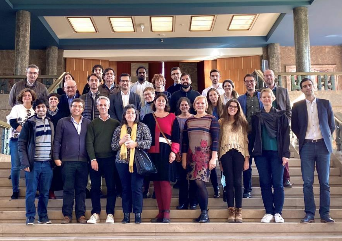
Work developed by Elisabete A. Silva, Haifeng Niu, Ana Paula Seraphim and Xinmeng Tu
In order to know more about our work on this project please see the following website:
https://emotionalcities-h2020.eu/
- Sensing Urban Dynamics through Crowdsourced Data with the Support of Machine Learning Techniques
Crowdsourced data such as social media data, points of interest and geotagged images has attracted the attention of urban researchers, as it provides first-hand information regarding human activities, perception and the interaction with the built environment, helping researchers illuminate a richer sense of what cities are all about from data itself. Despite the appealing potential of crowdsourced data in answering urban-related questions, there are challenges inherent to the whole process of transforming immense data into accurate and actionable insights in the urban domain, which overshadow the benefits of this type of data in well-designed cases of use. This research focuses on leveraging crowdsourced data in sensing urban dynamics by implementing advanced machine learning techniques to deal with hitherto unsolved challenges. The main aim is to contribute to the current knowledge on crowdsourced data-driven studies for better management and planning of cities. This thesis then demonstrates its application by carrying out three empirical studies of the Greater London – sensing urban function from points of interest data, sensing activity pattern from location-based social media data, and sensing public opinion from social media data.
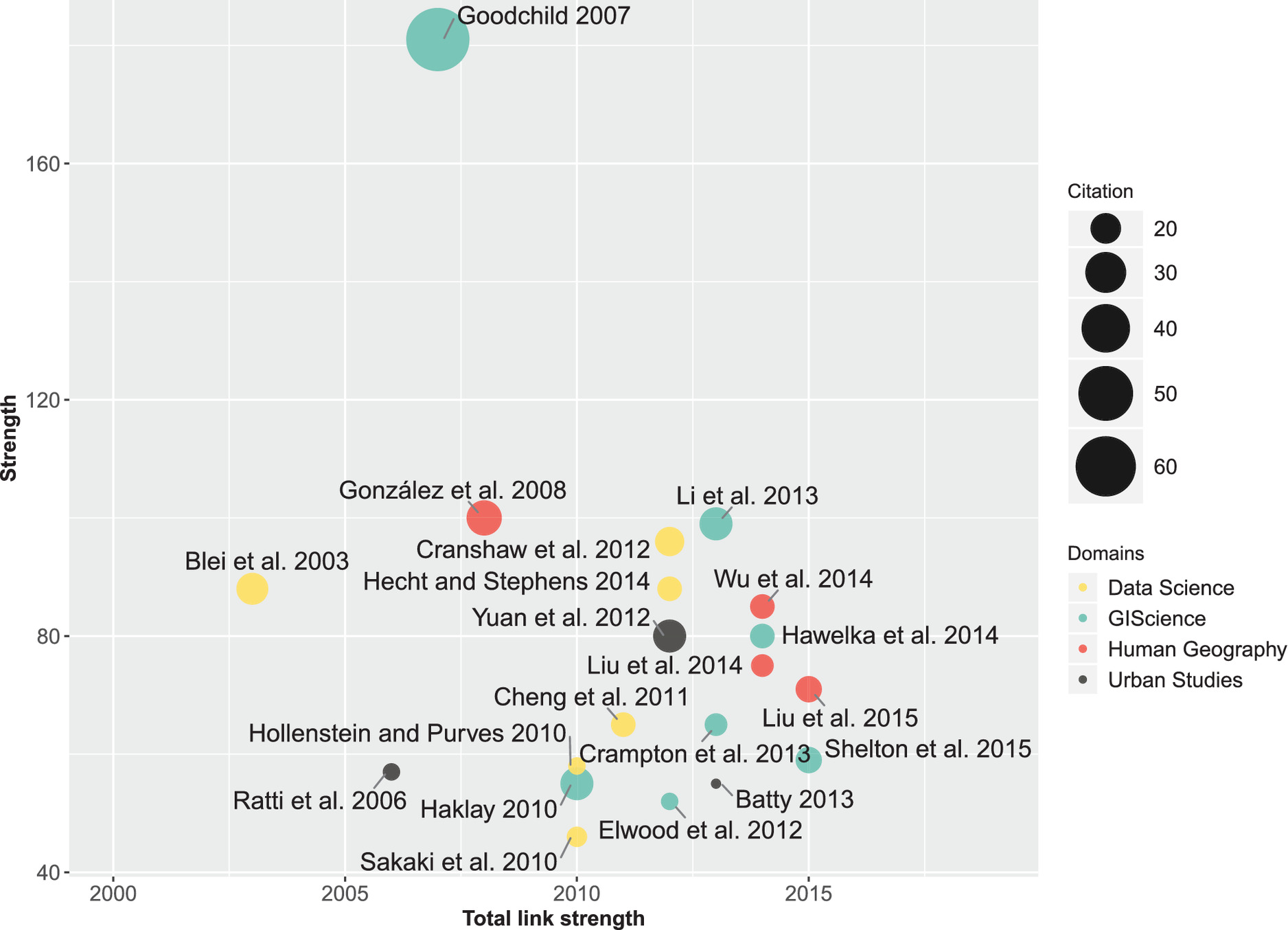
Work developed by Haifeng Niu and Elisabete A. Silva
In order to know more about our work on this subject please see following papers:
Chen, Y., Niu, H.*, & Silva, E. A. (forthcoming). The Road to Recovery: sensing public opinion towards reopening measures with social media data in post-lockdown cities.
- Towards smart city and smart transport in English metropolitan areas: enhancing the understanding and governance through multi-sourced data analysis
Researching data-driven smart city governance through applying advanced data analytics such as natural language processing and machine learning to multi-sourced urban big data, including official and crowdsourced data. Specifically studying activity-travel patterns of citizens and public attitudes towards governance issues. Also exploring how data-driven evidence can support smart governance. Current work includes using unsupervised and supervised algorithms to identify patterns and determinants.
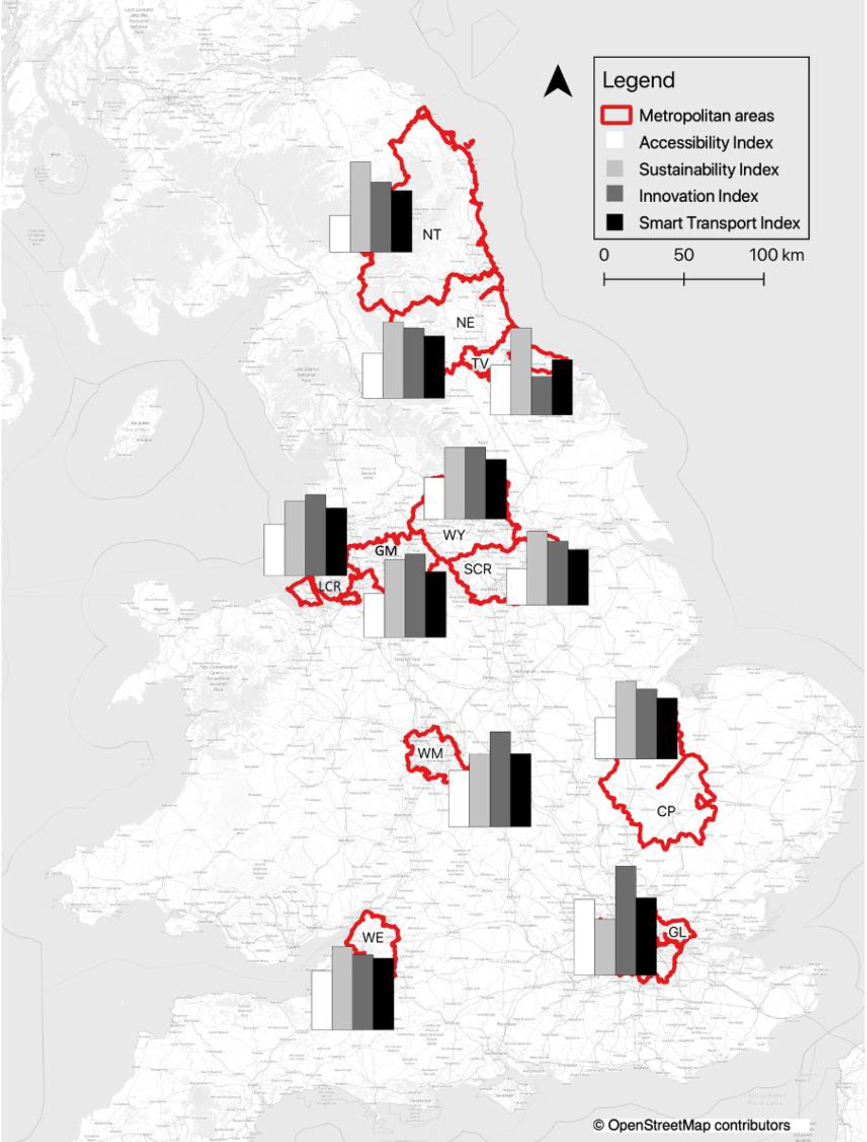
Work developed by Yiqiao Chen and Elisabete A. Silva
In order to know more about our work on this subject please see following papers:
Chen, Y., & Silva, E. A. (2021). Smart transport: A comparative analysis using the most used indicators in the literature juxtaposed with interventions in English metropolitan areas. Transportation Research Interdisciplinary Perspectives, 10, 100371.
Chen, Y., & Silva, E. A. (2021, April 6). Understanding of representative 24h travel activity sequences of Londoners. 29th Annual GIS Research UK Conference (GISRUK), Cardiff, Wales, UK (Online). https://doi.org/10.5281/zenodo.4665386
Chen, Y., Niu, H., & Silva, E. A. (forthcoming). The Road to Recovery: sensing public opinion towards reopening measures with social media data in post-lockdown cities.
- Addressing complexity in the role of green and blue spaces in achieving healthier cities
There is a growing body of evidence supporting the correlation between availability of natural spaces and population health improvement. However, more systematic evidence of how structural characteristics of natural spaces influence health, and how spatial scales, population groups, and urban contexts influence this process, are still lacking. In this context, this research explores associations between green-blue spaces characteristics and population mental health through the lens of complexity theory — using novel types of data (e.g. social media posts) — with the aim of achieving new holistic insights on how this complex system works. For this the research will start with a literature review of green-blue spaces spatial metrics used in health-related primary studies. And a meta-analysis of mental health impacts related to green-blue spaces exposure. The second part of the project will involve a spatial and dynamic analysis of remote sensing images, open mapping platforms, statistical year books, and twitter posts data in the case studies - London and Lisbon. This will generate maps of green–blue health metrics that capture baseline features important for population mental health. In the fourth chapter, we will develop an Agent Based Model (ABM), based on pattern-oriented modelling (POM) and ODD protocols, with a spatial-explicit visualization of agents' dynamic behavior within the urban natural environment; we will evaluate this ABM on the same case studies of chapter 3. This will help us explore the associations presented in the literature review and in the spatial analysis from a deductive perspective. This will also help us understand nonlinear associations, feedback loops, and emergent properties of the system, and allow us to test possible generalizations of model internal rules. We believe the combined results from these analysis will complement our understanding of how underlying mechanisms of this system work together in a mutually reinforcing way, better informing future planning and decision-making.
Work developed by Ana Paula Seraphim and Elisabete A. Silva
In order to know more about our work on this subject please see following papers
SERAPHIM, A.; ELISABETE, S. (2021). Literature review of Green–Blue Spaces and Health Research between 2000-2021: A Bibliometric Analysis. Paper presentation in the Healthy City Design 2021 International Congress. London, UK/ Online, October 11-14
- Simulating sustainable accessible urban form through Agent Based spatial modelling
The research aims to model the relationship between urban form and accessibility for different socio-economic groups using a case study of the Delhi metropolitan area. One of the primary objectives is to analyze and model how change in urban landform, affects the household segregation for different socio-economic groups in the city of Delhi using a synthesis of Statistical, Agent Based Model (ABM) and Neural Network (NN) Model. Another objective is to classify the street layout and street network and relate it with accessibility to nearby services using Network Analysis. The research findings are expected to conceptualize, analyze and propose new sustainable accessible urban forms.
Work developed by Aviral Marwal and ElisabeteA. Silva
Marwal, A., Silva, and E.A. (2021). Literature Review of Accessibility Measures and Models used in Land Use and Transportation Planning in last 5 years. Journal of Geographical Sciences. [Forthcoming]
- BEATIM- Built Environment Activity Travel Integrated Model
Travel diary data containing ca 116,000 individuals and 200,000 trips
Built environment data from various sources
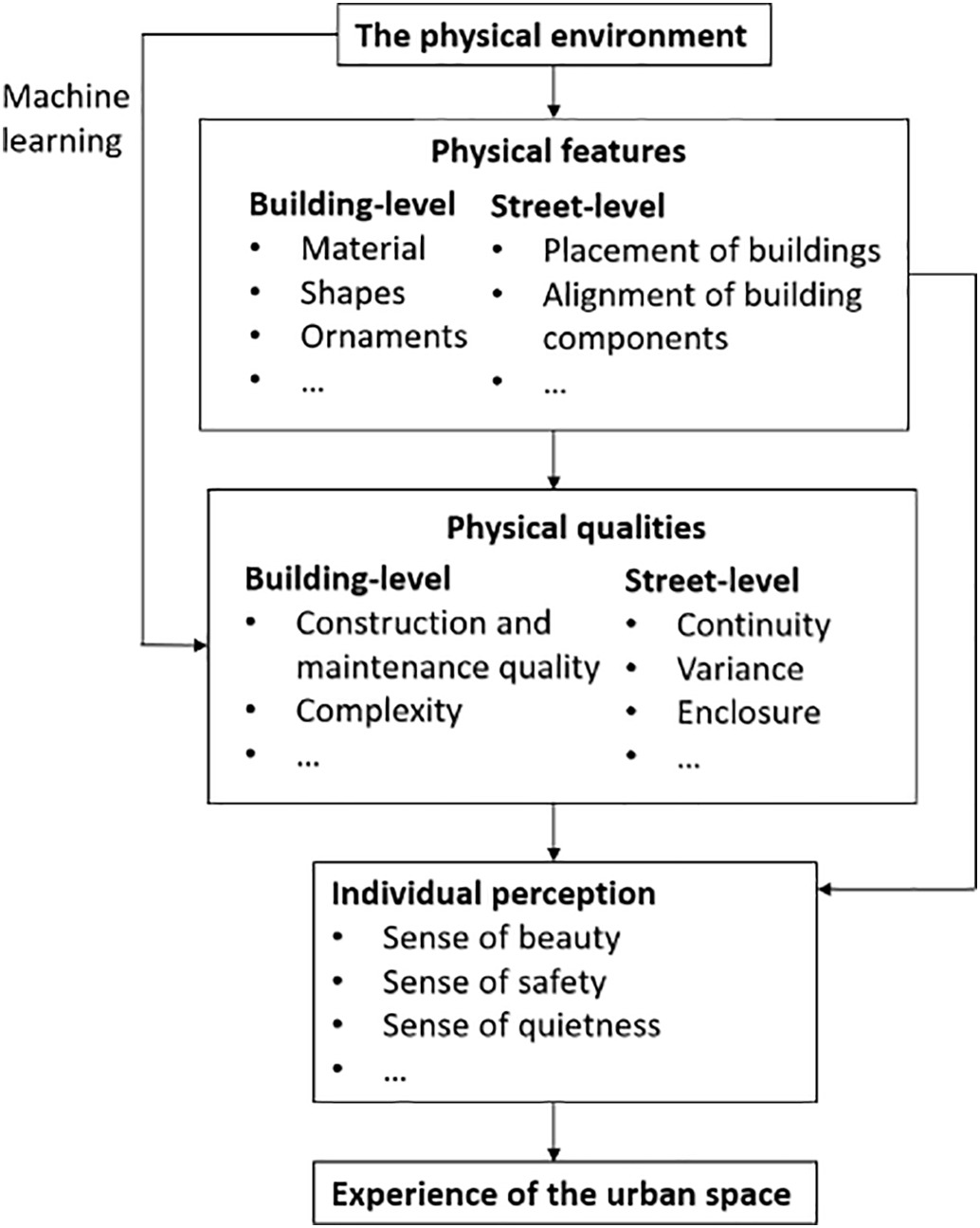
Planning & Transport -Urban big data analytics and application of deep learning
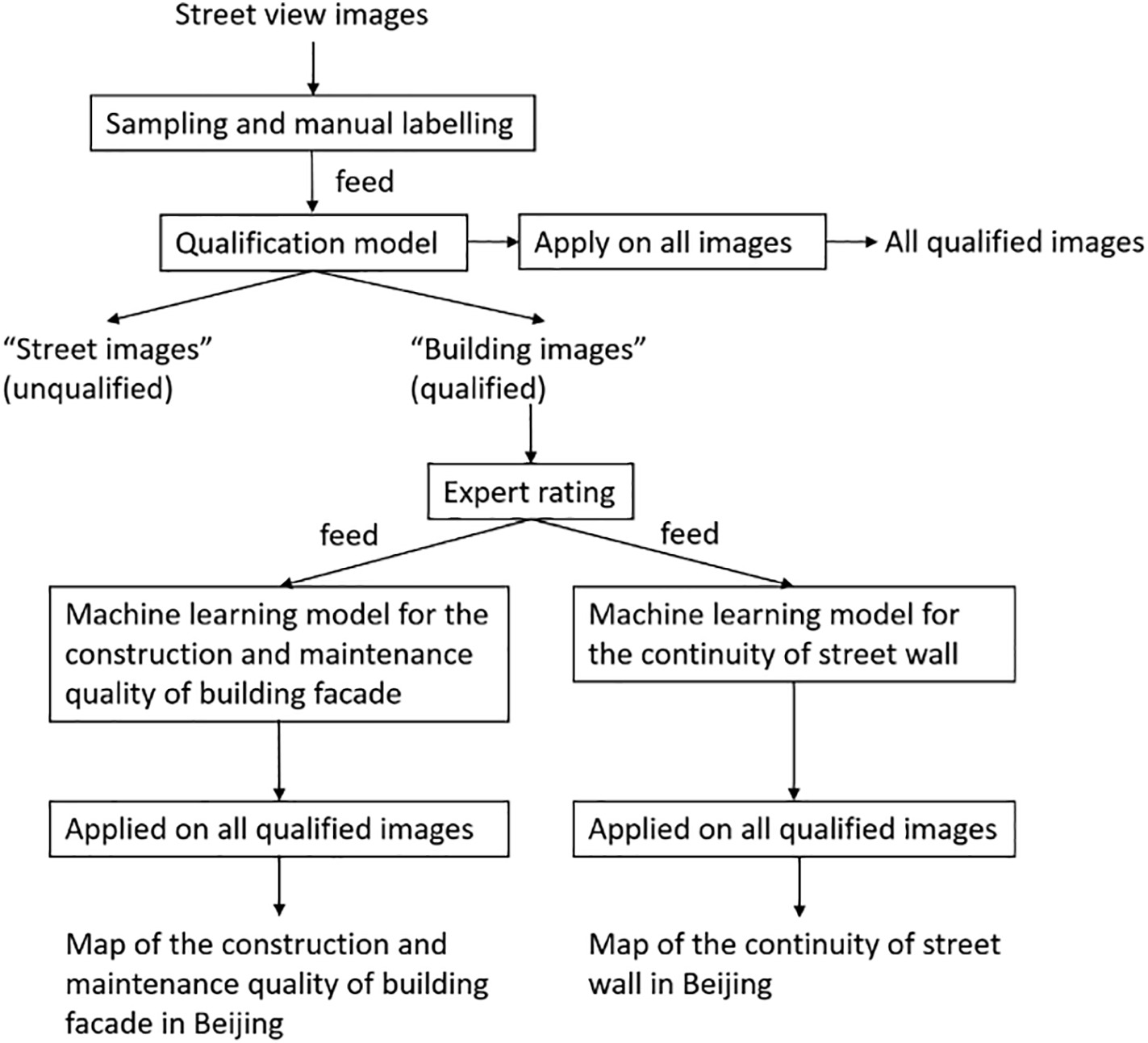
Deep learning the qualities of urban environment from street view images
Work developed by Lun Liu and Elisabete A. Silva
In order to know more about our work on this subject please see following papers:
•2017 A machine learning-based method for the large-scale evaluation of the qualities of the urban environment (L. Liu, C. Wu, H. Wang) CEUS, 65: 113-125
•2018 Block-level dynamics of socio-economic spatial differentiation in Beijing: Trends and processes (L. Liu, Y. Long) Urban Studies, doi.org/10.1177/0042098018757617
•2018 A decade of battle on PM2.5 in Beijing (L. Liu, J. Liu) Environment and Planning A: Economy and Space, doi.org/10.1177/0308518X18766633
- Refining Behavioural Theories and Rules in Agent-based Models (ABM) to Enhance Dynamic Simulation of Urban Growth
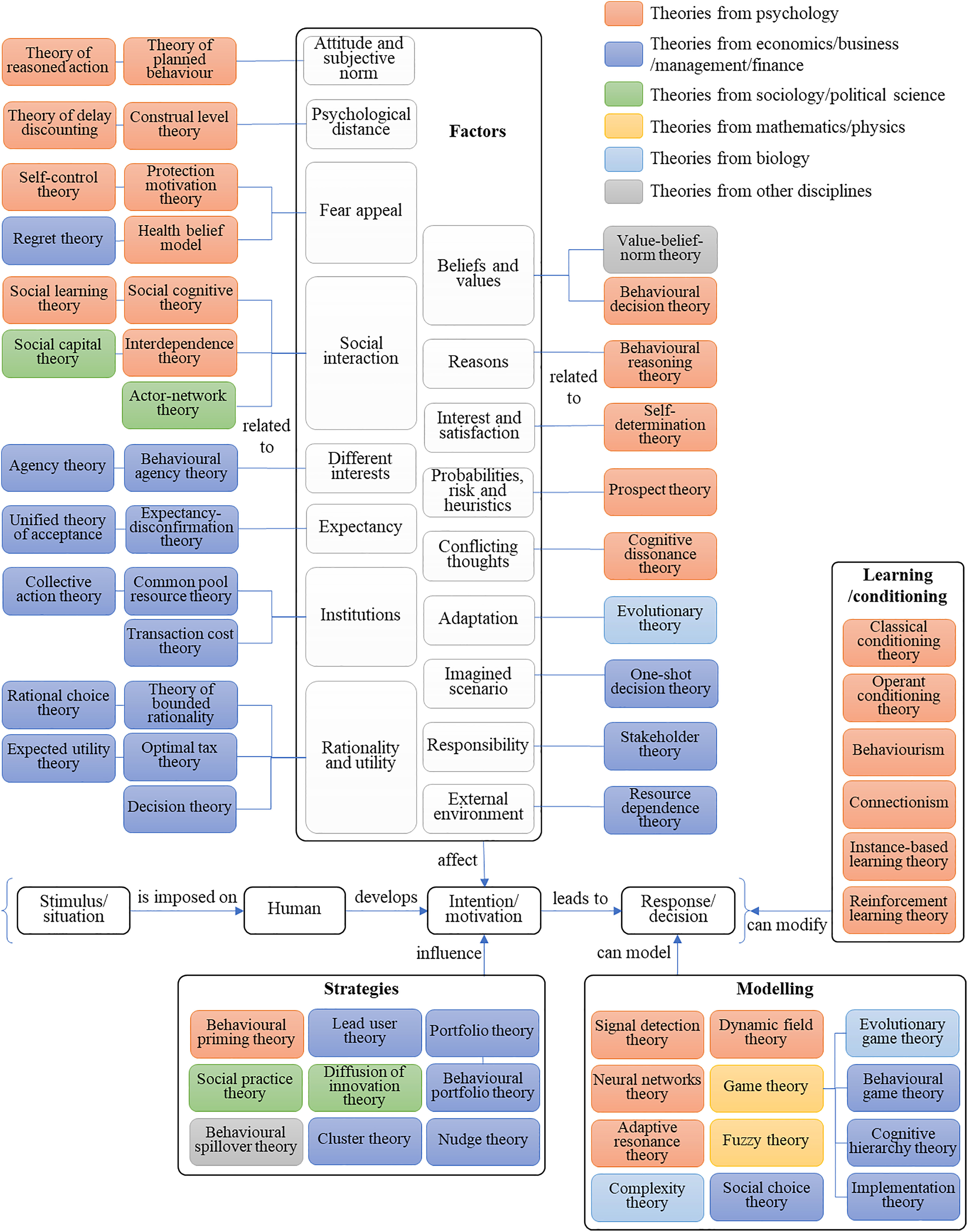
Understanding and predicting the spatial pattern of urban growth is greatly useful for planners to deliver evidence-based and adaptive policies to address current problems and pursue future sustainability. Harnessing technologies such as GIS, remote sensing and satellite imagery, approaches such as cellular automata (CA) and ABM have been applied to generate dynamic simulation to analyse urban growth. However, it tends to yet have limitations on taking complex agent behaviour into account, predicting behaviours based on a few quantitative factors with large assumptions. While using questionnaires to refine behaviours is clearly a step forward, lack of theoretical understanding of the behaviours and associated patterns is heavily constraining the development of ABM.
To close this gap in the knowledge, this PhD thesis aims to 1) understand the map of behavioural theories that generate variables and patterns, 2) refine the behavioural rules in ABM based on the applicable theories, and 3) test the model in different regions of the world using both quantitative and qualitative methods, adding sociological and psychological realms of research to the existing mathematical and physical approaches.
Work developed by Heeseo (Rain) Kwon and Elisabete A. Silva
In order to know more about our work on this subject please see following papers:
Kwon, H. R. and E. A. Silva (forthcoming) Mapping the landscape of behavioral theories: Systematic Literature Review
- Crowdsourced data in mining spatial urban activities
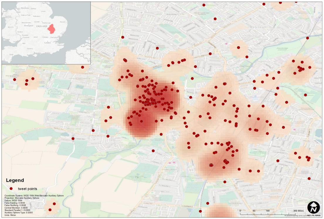
--the case of multi-dimensional analysis of Urban Segregation in Cambridge and Ningbo
This project focuses on the crowdsourced data harvesting and data-mining of the multi-dimensional mechanisms of urban segregation combining the geo-coding of information with the abundant attributes of this type of data. This project conducts pilots at Cambridge in the UK and then compare it with prior study of Ningbo in China trying to synchronise some of the data collection methods across the two case studies. We realized that by utilising crowdsourced data, it can leverage some of the advantages of geographic data and provide insights into socio-economic mechanisms behind the spatial-temporal dimension of urban activity. Also, to extend to social-spatial and economic-spatial characteristics instead of the spatial structure, this research provides a conceptual and methodological framework for analysing crowdsourcing data that is more sensitive to the social and economic relations embodied in spatial-temporal behaviours.
“Crowdsourced data” has been generated in great quantities with the development of the information and communications technology (ICT) from large and diverse groups of people or internet users. These new non-traditional datasets also have been introduced as a data source for urban analysis in recent studies. This paper provides a systematic review of how crowdsourced data contributes to mining urban activity, filling the gap that there is no review of this topic. It not only includes the data sources and application of crowdsourced data but also critically presents how the methods are applied to processing data and conducting multi-dimensional analysis.
Work developed by Haifeng Niu and Elisabete A. Silva
In order to know more about our work on this subject please see following papers:
Niu, H. and E. A. Silva (forthcoming) Crowdsourced Data in Mining Urban Activity: A Review of Data Sources, Applications and Methods
- From Big Data Sets to Collective Human Behavior Patterns and Urban Spatial Structure
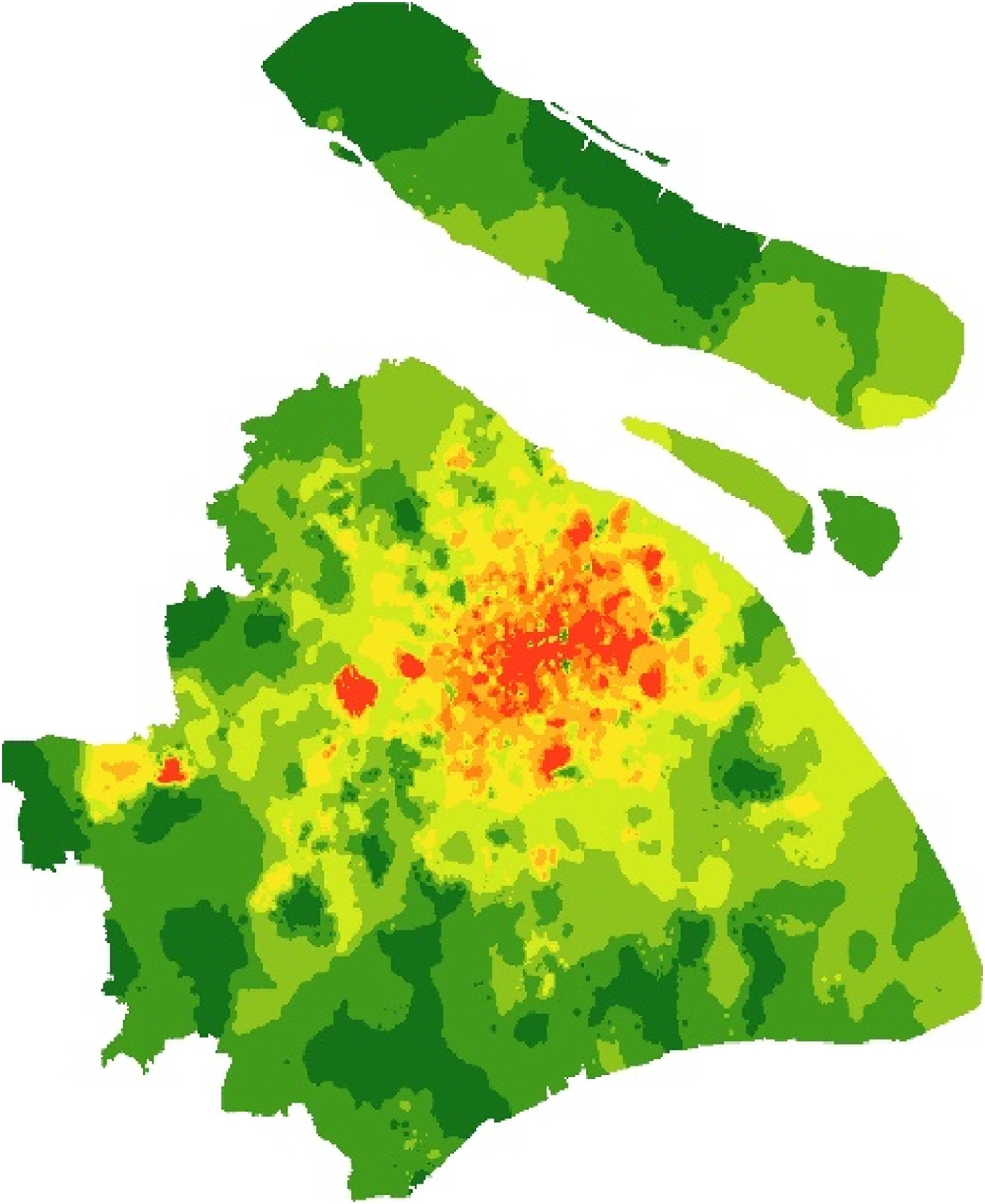
How to analyzing and simulating Spatial-Temporal Dynamics using big data? confirmatory analysis of existent data from sensors and big data from mobile devises (i.e. mobile-phone) on: 1 Population spatial distribution in Shanghai (Heat map, static metric and dynamic metric), 2 Urban Spatial Structure of Shanghai (residential areas, employment areas and leisure areas), 3. O-D distribution (real 4-step transportation, from big data to generalize human behavior patterns), 5. valuate the telationship between the spatial population flow pattern and land use\road\underground\planning policy\space syntax
How to incorporate human behavior patterns with ABM model to simulate the future population spatial distribution and future O-D distribution
Work developed by Chaowei Xiao and Elisabete A. Silva
Case study: Shanghai
- Economics-based Dynamic Simulation (ABM) of Locating and Structuring Regional Industrial Development
Normal 0 false false false EN-US ZH-CN X-NONE The whole research follows the logic of understanding, explanation and prediction of the co-evolving firm-industry-region system in a step-by-step order: what are the evolutionary spatio-temporal patterns of firm location choices, industrial structures and regional development paths and their interrelations? To what extent are these economic landscapes determined by intrinsic motivations and external incentives? How do these economic landscapes influence the long-term regional economic efficiency and stability? A multilevel micro-meso-macro framework on the basis of spatial dynamic analysis is proposed drawing upon theories and methods from complexity theory, evolutionary economics, evolutionary economic geography and spatial econometrics. Micro-level firms, meso-level sectors, macro-level the economy as a whole and their interactions are the key to this framework.
Work developed by Yiwen Qiu and Elisabete A. Silva
In order to know more about our work on this subject please see following paper:
Y. Qiu and E. A. Silva (forthcoming) Understanding the Industrial Evolution from A Path-dependent Development Perspective: the Chinese Case
- Metrics for growth and shrinkage
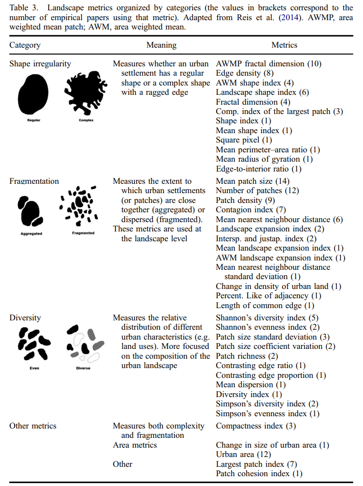
Comprehensive portfolio of spatial metrics for growth and shrinkage; contribute to the development of quantitative methods that quantify these patterns, focusing on spatial metrics and aiming at filling the gaps in the current methods; present a set of metrics (both new metrics and metrics adapted from the literature) which can be used to measure spatial patterns of growing and shrinking cities, and perform an empirical application of these metrics. Understand the process of land use change, particularly the structural factors behind growth and shrinkage; identify particular spatial patterns that are characteristic of growing and shrinking cities, taking into account that these two processes can occur simultaneously and at different spatial scales;
Work developed by Jose Pedro Reis and Elisabete A. Silva
Case studies Espinho and Vila Real, Portugal
More than 300 spatial metrics were surveyed
In order to know more about our work on this subject please see following papers:
Reis, J.; E. A. Silva and P.Pinho (2016) Spatial Metrics to Study Urban Patterns in Growing and Shrinking Cities. (with J. Reis). Urban Geography. 37 (2): 246-271
Reis, J.P. and E. A. Silva (2014) Measuring space: a review of spatial metrics for urban growth and shrinkage (with J. Reis). In: The Routledge Handbook of Planning Research Methods (Eds. Elisabete A. Silva, Patsy Healey, Neil Harris and Pieter van den Broeck), Routledge – 2015 – 530 pages
- BM4SIS model - Business models for sustainability
What is the impact of sustainable business model innovation on the industrial system? This research aims to conduct ‘experiments’, combining SBMs, and other agent behaviours, in a ABM to understand the implications for system level outcomes (energy use, resource depletion, wealth). Configurations (describing what gets made where and how including the physical network and value network configuration) that emerge for a given experiment will be captured. These configurations will be assessed for their ability to deliver sustainability at the system level.
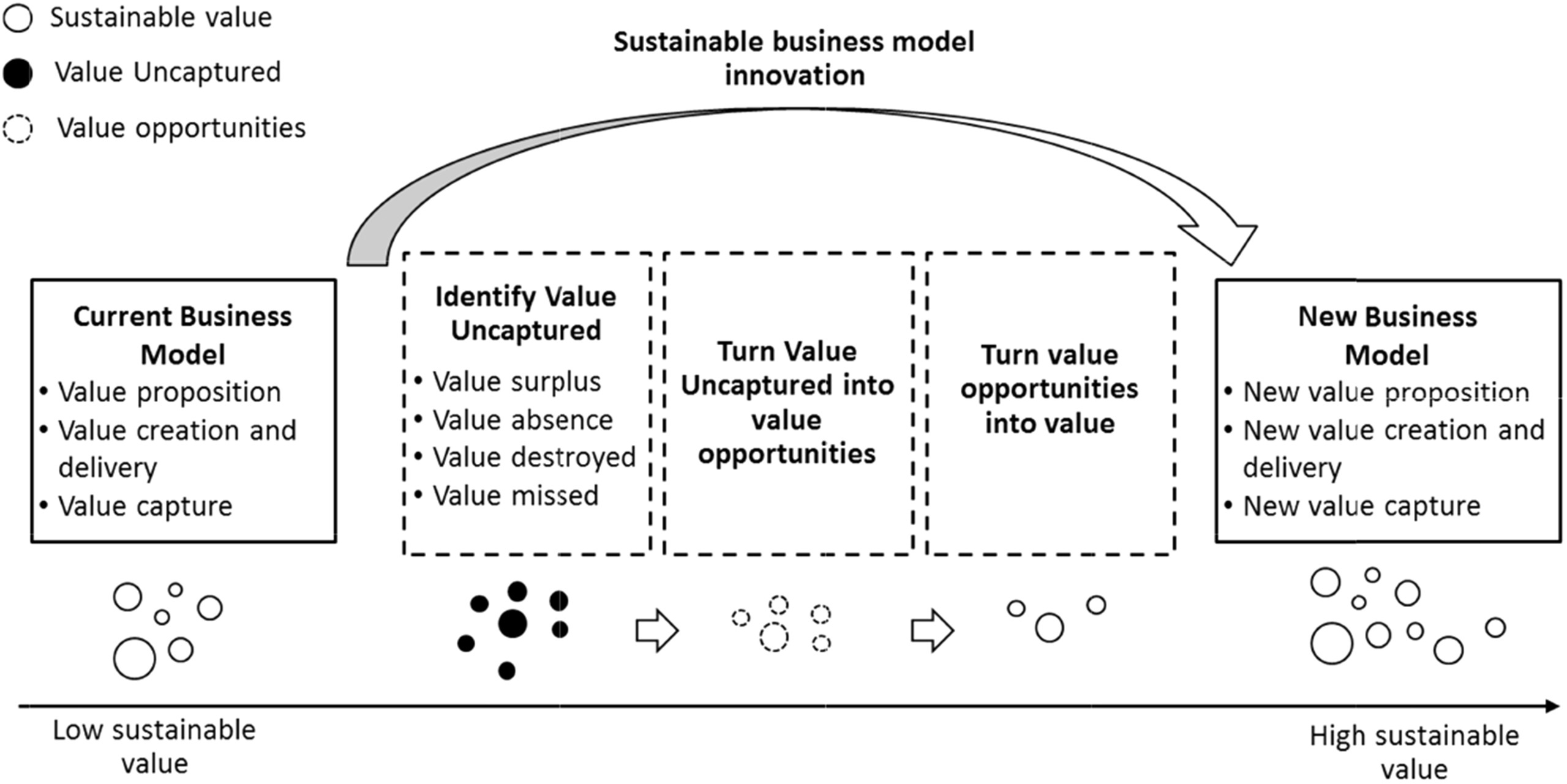
Model developed jointly by Elisabete A. Silva (at Dep. Land Economy) and Steve Evans, Doroteya Vladimirova, Maria Holgado Granados, Miying Yang, Kirsten van Fossen (Dep. of Engineering - Institute for Manufacturing)
- CID-USST model - Dynamic models for creative cities/firms/industries
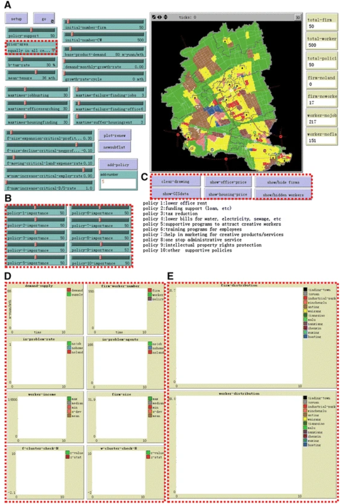
What factors determine the location of creative industries? ; Is the strategy of creative industries’ parks effective in promoting creative industries/firms?; In the development of creative industries what are the land market and urban spatial structure consequences? And what are the policy implications? How can we sustain the development of the creative industries? Is tax reduction, land rent reduction and trade promotion enough?; How can we observe the evolution of offer/demand dynamics in available office/industry space, residential space, and propose sustainable policies? ; What are the location determinants for both the firms and the workers
Work developed by: Helin Liu and Elisabete Silva (2011-2013) and expanded further by Helin Liu, Qian Wang, Elisabete Silva, Yalan Li and Yan Qin (2013 - 2015)
- 4CMR' s Agent-based model of global carbon mitigation through bilateral negotiation under economic constraints
What set of conditions would be effective in moving nations, regions and the global economy onto the energy transformation and emissions reduction pathways necessary for significant emissions reductions in the aggregate? The current paper explores this question through the use of an agent-based model. It seeks through this modelling, to examine if global carbon mitigation is achievable with no global unitary framework but through bilateral negotiation; and to explore what mitigation level can be reached in three different mitigation schemes
Model developed by Doug Crawford-Brown, Helin Liu and Elisabete A. Silva
Model applied to world - Annex I and non-Annex I countries
Download/click here https://www.4cmr.group.cam.ac.uk/research/projects/agent-based-modelling
- DG-ABC model - ABM and CA integrated model of land transaction
DG-ABC is an integrated model that incorporates ABM (Agent Base
Model), CA (Cellular Automaton) and Genetic Algorithm (GA) to include both spatial and a-spatial dynamics in an urban system in order to supply a new solution for urban studies. In our model (DG-ABC stands for ‘Developing Genetic-Agent Based Cells’), the social economic behaviours of heterogeneous agents (resident, property developer and government) will be regulated by GA and Theory of Planning Behaviour (TpB). With a pilot study conducted with the model we analyzed how the macro level of the spatial pattern change (the emergence phenomena) is produced from the interactions of actors at the micro level (the heterogeneous behaviours and interactions between agents, and the discrete
spatial dynamics represented by CA).
Model developed by Ning Wu and Elisabete A. Silva
In order to know more about our work on this model please see following papers:
Wu, N. and E. A. Silva (2013) DG-ABC: An Integrated multi-agent and cellular automata urban growth model. Technologies in Urban and Spatial Planning: Virtual Cities and Territories? (Eds. Nuno Norte Pinto, José António Tenedório, António Pais Antunes and Josep Roca ), Springer
Wu, N. and E. A. Silva (2010) Integration of genetic agents and cellular automata for dynamic urban growth modelling: pilot studies. (With N. Wu) WCTR-World Congress of Transportation Research, July, Lisbon, Portugal. Conference program: page 61; Book of Abstracts: (digital format paper 1858 (page 119) ; PowerPoint: 15 slides, Paper: 10 pages. http://intranet.imet.gr/Portals/0/UsefulDocuments/int_04_papers_authorin...
Wu, N. and E. A. Silva (2009) Integration of genetic agents and cellular automata for dynamic urban growth modelling. (With N. Wu) Geocomputation, November, Australia. Paper 5 pages. http://www.geocomputation.org/2009/PDF/Wu_and_Silva.pdf
- CVCA model - countervailing CA of landscape strategies
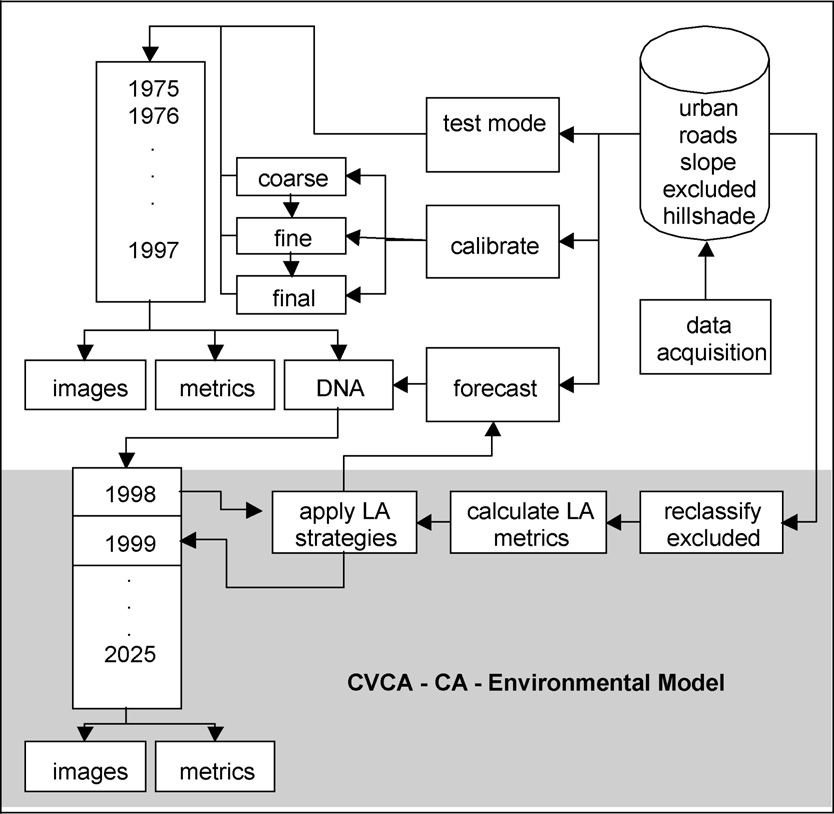
The CVCA model was conceived to provide answers to questions such as: What is the state of the landscape? Which landscape strategies are predominant? How can one create a different image of the metropolitan area?What is the dominant pattern (corridor, patch)? Are the strategies promoting connectivity? Which landscape metrics increase the dominant strategy?
Model developed by Elisabete A. Silva
Model applied to Lisbon and Porto Metropolitan Areas
In order to know more about our work on this model please see following papers:
Silva, E. A. J. Wileden, J. and J. Ahern (2008) Strategies for Landscape Ecology in Metropolitan Planning: Applications Using Cellular Automata Models., Progress in Planning, 70(4):133-177 - ISSN: 0305-9006
- SLEUTH model - CA model of urban and land use change
SLEUTH is a tightly coupled, modified cellular automaton model of urban and other land class change. Its main component is the Clarke Urban Growth Model (UGM) which drives a second component, the Deltatron land cover model.
** All C language code and libraries, and a sample data set, demo_city, is contained within the compressed SLEUTH3.0beta file. Information on file structure, decompression and how to run SLEUTH may be found on theImplement pages. The Implement page instructions for SLEUTH3.0beta may be used for SLEUTH3.0beta_p01. To post questions or information on the download process please refer to the project discussion board.
http://www.ncgia.ucsb.edu/projects/gig/Dnload/download.htm
In order to know more about our work on this model please see following papers:
Silva, E. A. and K. Clarke (2005) Complexity, Emergence and Cellular Urban Models: Lessons Learned from Appling SLEUTH to two Portuguese Cities. European Planning Studies, 13 (1): 93-115 – ISSN: 0965-4313
Silva, E. A. and K. Clarke (2002) Calibration of the SLEUTH Urban Growth Model for Lisbon and Porto, Portugal. Computers, Environment and Urban Systems, 26 (6): 525-552 - ISSN: 0198-9715
- Economics-based Dynamic Simulation (ABM) of Locating and Structuring Regional Industrial Development
The whole research follows the logic of understanding, explanation and prediction of the co-evolving firm-industry-region system in a step-by-step order: what are the evolutionary spatio-temporal patterns of firm location choices, industrial structures and regional development paths and their interrelations? To what extent are these economic landscapes determined by intrinsic motivations and external incentives? How do these economic landscapes influence the long-term regional economic efficiency and stability? A multilevel micro-meso-macro framework on the basis of spatial dynamic analysis is proposed drawing upon theories and methods from complexity theory, evolutionary economics, evolutionary economic geography and spatial econometrics. Micro-level firms, meso-level sectors, macro-level the economy as a whole and their interactions are the key to this framework.
